Hawaii Braces for Potential Back-to-Back Hurricanes: Gilma Could Threaten Less Than a Week After Hone
Tropical Storm Hone began passing through the islands as a Category 1 Hurricane on Aug. 25, weakening to a tropical storm along the way.
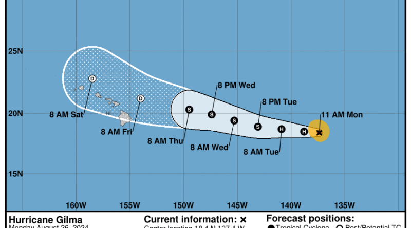
The Hawaiian Islands are at risk of facing consecutive storms as the National Hurricane Center (NHC) predicts the arrival of Hurricane Gilma within striking distance by Labor Day Weekend – less than a week after Hurricane Hone.
Ian Morrison, the forecaster at the National Weather Service’s Honolulu office, mentioned that seeing storms occur five days apart is not unprecedented when the East Pacific becomes active in generating multiple storms, although it is not an annual event.
Pacific hurricanes typically originate in the eastern Pacific near the coast of Mexico and move westward. Currently, there are three named storms in the Pacific, with Tropical Storm Hector trailing behind Gilma.
The NHC noted a slight increase in intensity in its latest advisory, mentioning, “Gilma’s eye continues to become more symmetric with a warming eye and impressive convection surrounding the eye.” However, it also expects a gradual weakening of the storm to begin tonight, with a more consistent weakening trend from Aug. 27, ultimately becoming a post-tropical storm in the next four days.
Morrison explained that the weakening of Gilma would be caused by increased wind shear and colder waters. It is anticipated to stay on the northern side of the islands while Hone’s path remains to the south.
Gilma reached its peak strength as a Category 3 Hurricane on Aug. 22, recording sustained winds of up to 125 mph. Once its remnants approach Hawaii, significant rainfall is expected, but without the tropical-storm-force winds that accompanied Hone.
“We are hoping for the rain now to kind of alleviate the drought conditions on the leeward side of the island,” Morrison mentioned.
However, Morrison emphasized that it is too early to predict precisely how Gilma will impact the Hawaiian Islands.