Typhoon Shanshan Approaching Japan’s Coastline
The storm was last measured as a Category 2 Hurricane, with maximum sustained wind speeds of 100 mph.
Nearly one million people have been evacuated as Typhoon Shanshan is set to make landfall in Japan in the early morning of Aug. 29, local time.
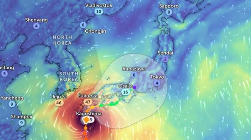
Radar imagery as of 4 p.m. EST on Aug. 28 showed the storm’s center about to make landfall on the island of Kyushu, just south of Nagasaki. The typhoon is inching forward at approximately 8 mph.
“This is a dangerous system,” the Joint Typhoon Warning Center (JTWC) stated. ”Possible risks include damaging winds, heavy rainfall, storm surge, rough seas, mudslides, and flash flooding.”
Boasting maximum sustained wind speeds of 100 mph, its strength was equal to a Category 2 Hurricane on the Saffir-Simpson scale. This is a slight decrease from 112 mph recorded earlier, which would have made it equal to a Category 3 hurricane.
However, wind gusts of up to 114 mph are still being recorded.
While its center spins in the south, Shanshan’s outer bands are already stretched across the southern half of the nation, covering major cities such as Osaka, Nagoya, and Kyoto, bringing rains and winds as far north as Tokyo.
Related Stories


“Special warnings have been issued for the Satsuma, Osumi, Tanegashima, and Yakushima regions,” the Japanese Meteorlogical Agency announced on X. ”Please be on high alert for high winds, high waves, and high tides.”
Over the next few days, Shanshan’s eye is expected to cut north across Kyushu near Kumamoto, still south of Nagasaki, and skirt the southeastern coastline of Shikoku and Honshu Islands, moving past Osaka toward Nagoya.
In anticipation of its arrival, authorities previously ordered the evacuations of more than 800,000 people in Kagoshima prefecture on Kyushu, as well as the coastal prefectures of Aichi and Shizuoka, near Fuji.
The Japanese Meteorological Agency expected the storm to bring record heavy rainfall for Miyazaki Prefecture, located on the southeast corner of the island, and the risk of life-threatening landslides and floods was increasing. Storm surge warnings have also been issued.
Nearly 24 inches of rainfall is expected to drop on Kyushu in the next 24 hours. Radar imagery showed the southern half of Kyushu under rain pouring at a rate of more than half an inch per hour.
“Maximum caution is required given that forecasts are for strong winds, high waves, and high tides that have not been seen thus far,” Satoshi Sugimoto, the agency’s chief forecaster, previously told members of the press at a news conference.
Typhoon Shanshan arrives in Japan one week after Typhoon Ampil, which also reached the size of a Category 2 hurricane and caused some transportation disruptions, evacuations, and blackouts. However, Ampil never officially made landfall.
The Associated Press and Reuters contributed to this report.