Easter Weather Forecast: Tornadoes, Hail, and Intense Thunderstorms Expected in Some US Regions
The threat of severe storms is anticipated to reach its peak during the afternoon and early evening hours.
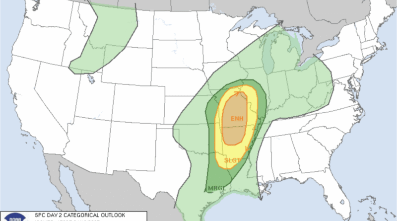
This Easter Sunday, people living near the Mississippi River may face the risks of tornadoes and hail as severe weather moves from Texas to the Ohio Valley.
The center has specifically indicated an enhanced risk for severe thunderstorms across much of Northern Arkansas, Missouri, and far western Illinois, following earlier severe thunderstorm activity in Texas.
The severe storm threat is predicted to peak in the afternoon and early evening, with the highest probability for tornado formation occurring from northern Arkansas to central Missouri.
Rain and thunderstorms are expected to begin early in the day across Missouri and Illinois, with storm development likely in the early afternoon over eastern Kansas and Oklahoma. A line of supercells could potentially form stretching from the Iowa/Missouri border down to Arkansas.
These storms may produce hurricane-force winds (74 mph or higher) and a 15 percent chance of hail measuring two inches or more in diameter, affecting a region from Shreveport, Louisiana, to the southeastern corner of Iowa.
Related Stories


This adverse weather could disrupt Easter Sunday plans for many Americans who typically enjoy outdoor activities, attend church services, and partake in springtime brunches and family gatherings.
Meanwhile, Texas and the southern plains are continuing to face severe weather on April 19.
The weather prediction center issued a warning earlier today stating, “Scattered severe thunderstorms are likely across parts of Texas into southern Missouri, primarily in the afternoon and evening hours. There is potential for large to very large hail, damaging winds, and a few tornadoes.”
The warning indicated, “Scattered large hail, with isolated reports of very large hail up to 2.5 inches in diameter, is possible,” affecting areas within 50 statute miles east and west of a line extending from 15 miles northwest of McAlester, Oklahoma, to 10 miles southeast of Mineral Wells, Texas. Additionally, there could be “scattered damaging wind gusts reaching 70 mph.”