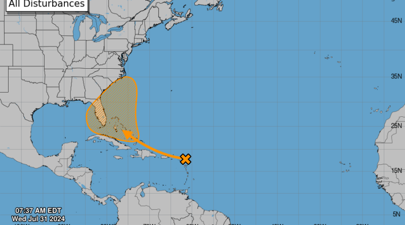
Possible Tropical Depression Developing off Florida Coast
If it strengthens, it will be the second storm to affect the United States this season, following Hurricane Beryl, which struck Texas in early July.
TAMPA, Fla.—Floridians and Bahamians could be facing their first named storm of the 2024 season by next week.
The National Hurricane Center (NHC) is watching “a large tropical wave” that is set to enter the Caribbean on July 31, approaching the Lesser Antilles.
That stretch of smaller islands includes the Virgin Islands and Trinidad and Togabo. Satellite imagery shows the budding storm on the northern edge of that stretch, nearing Puerto Rico.
As of 8 a.m. EDT on July 31, there was a 60 percent chance of the tropical wave forming into an organized storm over the next seven days as it makes its way west-northwest across the Caribbean.
There is a “near zero percent” chance of the storm forming within the next 48 hours.
To become a tropical depression, this tropical wave would have to develop into a cyclone with “organized deep convection” and surface winds moving counter-clockwise around a “well-defined center,” producing maximum sustained winds of 38 mph or less, according to the NWS.
If the system takes shape, it will be introduced as Tropical Depression Debby.
Numerous thunderstorms are possible, as well as excessive rainfall that could flood urban areas, small streams, and roads. Residents are also warned of the possibility of isolated flash flooding.
“A vigorous tropical wave will continue to impact the regions on Thursday with trailing moisture through early in the weekend, maintaining wet and unstable weather conditions across the islands with the potential for flooding impacts,” the NWS stated.
The exact track of the would-be storm is still unknown. It is expected to turn north-northeast at some point, but the jury is out on where it will make that turn within the vicinity of the Sunshine State. It could affect the Atlantic coast of Georgia and the Carolinas.
If the storm becomes stronger, it will be the second one to affect the United States this season, following Hurricane Beryl, which struck Texas on July 8.
Even though it made landfall only as a Category 1 hurricane, Beryl was able to inflict catastrophic damage on the Houston/Galveston Bay area and the surrounding Texas Gulf Coast.
Beryl’s diminishing bands stretched across the continent all the way to Canada, delivering record-setting tornados and fatal flooding.
Hurricane season began on June 1 and will run through Nov. 30.


