Tropical Storm Francine develops in the Gulf and is anticipated to make landfall in Louisiana
The National Hurricane Center has issued a warning that some levees may be breached by storm surges.
Authorities are alerting the public about Tropical Storm Francine, which has emerged in the western Gulf of Mexico on Sept. 9. It is expected to strengthen and become the first named storm in the Atlantic in over three weeks.
With maximum sustained winds of 50 miles per hour, the storm was located 245 miles southeast of the Rio Grande’s mouth.
Tropical-storm-force winds are extending 160 miles from the storm’s center.
A hurricane watch has been issued for most of Louisiana’s Gulf Coast, from Cameron to Grand Isle.
Additionally, a tropical storm watch remains in effect for areas near the coast, including Lake Pontchartrain, Lake Maurepas, west of Grand Isle to the mouth of the Pearl River near Mississippi, and from Cameron to just east of High Island, Texas.
A tropical storm watch is in place for the Rio Grande area from Barra del Tordo, Mexico, to Port Mansfield, Texas.
Although it is expected to stay offshore, meteorologists at the National Weather Service office in Brownsville, Texas, have reported nearly three inches of rainfall between 12 a.m. and 9:45 a.m. on Sept. 9.
There is also a storm surge watch for the coast from High Island, Texas, to the Alabama-Mississippi Border.
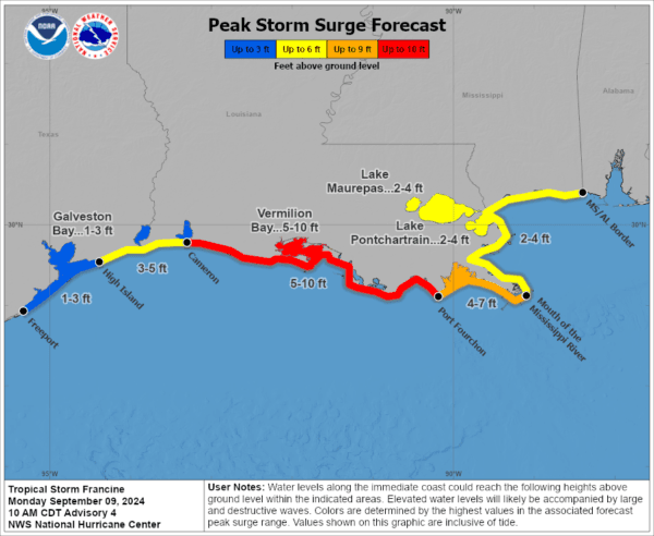
The National Hurricane Center (NHC) has projected a storm surge of five to 10 feet between Cameron, Louisiana, and Port Fourchon, Louisiana. From there, four to seven feet of surge is anticipated up to the mouth of the Mississippi River.
Other areas, including Lake Pontchartrain and Lake Maurepas, may experience two to four feet of surge.
Between Cameron, Louisiana, to High Island, Texas, a surge of three to five feet is expected, with one to three feet predicted for Galveston Bay.
The NHC believes the water levels will not reach levees but could cause some flooding. The center also warns that the deepest water and surge will be near the immediate coast, accompanied by large and dangerous waves.

The National Hurricane Center’s projected storm surge from Tropical Storm Francine as of 10 a.m. local time on Sept. 9, 2024. National Hurricane Center/National Weather Service
In terms of rainfall, the NHC anticipates four to eight inches of rain from Francine, with localized amounts up to 12 inches possible across parts of Texas, Louisiana, and Mississippi until Sept. 12.
Emergency resources, including swift water rescue boat squads, marine units, troopers, helicopters, and medical task forces, are on standby. Transportation department personnel are ready to monitor road conditions.
Governor Abbott emphasized readiness and urged Texans to take precautions and have an emergency plan ready for potential tropical weather impacts.
Louisiana is also gearing up for the storm, with the Governor’s Office of Homeland Security and Emergency Preparedness launching an updated version of its preparedness mobile app.
GOHSEP Director Jacques Thibodeaux emphasized the importance of preparedness and encouraged everyone to utilize the updated app for planning purposes.
If Francine escalates into a hurricane, it will be the second one to impact the Texas and Louisiana Gulf Coast this season, following Hurricane Beryl.


