
Hurricane Ian Forms, Forecast to Hit Florida Soon
Distressed Patriotic Flag Unisex T-Shirt - Celebrate Comfort and Country $11.29 USD Get it here>>

Hurricane Ian formed in the Caribbean Sea on Monday morning as federal forecasters predicted the storm will strengthen before ultimately slamming into western Florida.
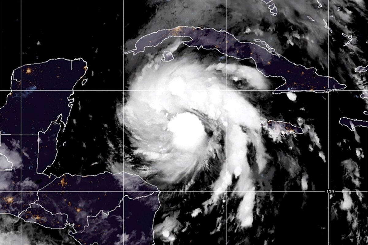
With 75 mph winds, the Category 1 storm is currently 90 miles west of the Cayman Islands and some 275 miles southeast of western Cuba, according to an 8 a.m. Monday update provided by the National Hurricane Center (NHC). Hurricane warnings were in effect for the Cuban provinces of Isla de Juventud, Pinar del Rio, and Artemisa as well as Grand Cayman island.
Officials said the system is expected to become a major hurricane—a storm system that is Category 3 or greater—by Monday evening. A Category 3 hurricane has 111 to 129 mph winds
An updated NHC “cone of uncertainty” shows Ian is slated to hit western Cuba as a major hurricane by 2 a.m. Tuesday. After hitting the island, the storm is expected to remain a major hurricane before tracking to the north-northwest, where it is then forecast to impact central western Florida, possibly bringing significant impacts to the Tampa area around early Thursday morning, according to NHC modeling.
Ian, according to the latest model, will weaken to a Category 2 or Category 1 hurricane before striking around Florida’s Big Bend Coast area on Friday morning at around 2 a.m. A tropical storm warning is in effect for the lower Florida Keys from Seven Mile Bridge westward to Key West, the NHC said. No hurricane warnings or watches have been issued for Florida so far.
Florida Gov. Ron DeSantis declared a state of emergency for every county in the state this past weekend, while President Joe Biden approved an emergency declaration that will free up federal resources to deal with the storm system. The president postponed a scheduled Sept. 27 trip to Florida because of the storm.
Some forecasters say Ian could become a Category 4 storm with 130 to 156 mph winds as it approaches Florida. “In just a few days, Ian is likely to be a dangerous, major hurricane,” AccuWeather Senior Meteorologist Adam Douty said.
On Sunday, DeSantis urged residents to get food, water, medicine, fuel, and batteries due to possible power outages and widespread damage. Evacuations will likely be ordered in the coming days, the governor said, adding that it’s still not clear when Ian will strike the state.
“Expect heavy rains, strong winds, flash flooding, storm surge, and even isolated tornadoes. Make preparations now,” he said Sunday in a news conference. “Anticipate power outages. That is something that is likely to happen with a hurricane of this magnitude.”
Flash flooding is possible in the Florida Keys and Florida peninsula through midweek, and then heavy rainfall was possible for north Florida, the Florida panhandle, and the southeast United States later this week, officials said.
The Associated Press contributed to this report.

Follow
Jack Phillips is a breaking news reporter at The Epoch Times based in New York.


