Rising Rivers and Flash Floods Endanger Waterlogged Communities Across the US
HOPKINSVILLE, Ky.—Yet another wave of heavy rainfall and flash flooding was anticipated on Saturday for regions in the South and Midwest that are already saturated from days of intense storms, some of which have produced fatal tornadoes.
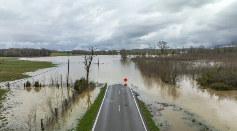
The central U.S. has seen continuous bouts of heavy rain, resulting in rapidly rising waterways and prompting a series of flash flood emergencies in Missouri, Texas, and Arkansas. According to the National Weather Service, 45 river sites across several states were projected to reach major flood stage, leading to significant flooding of properties, roadways, bridges, and other essential infrastructure.
At least seven individuals lost their lives as tornadoes rolled through, devastating entire communities, with additional tornado threats likely this weekend. In Kentucky, flooding claimed the lives of two more victims: a 9-year-old boy swept away on Friday as he headed to school, and a 74-year-old man whose body was discovered on Saturday inside a vehicle fully submerged in Nelson County, authorities reported.
Interstate trade is also being impacted; severe flooding across a corridor that includes prominent cargo hubs in Louisville, Kentucky, and Memphis could result in shipping and supply chain disruptions, stated Jonathan Porter, chief meteorologist at AccuWeather.
This surge in extreme weather coincides with a period in which nearly half of the NWS offices are experiencing 20% vacancy rates, a situation worsened by job cuts during the Trump administration — double that of ten years ago.
Downtown Hopkinsville, Kentucky, reopened early Saturday following the retreat of floodwaters from the Little River, providing a much-needed break, though more rainfall was still expected on Saturday and Sunday, as noted by Mayor James R. Knight Jr.
Related Stories


Intense rainfall since Wednesday transformed the downtown area of the city with a population of 31,000 into a lake by Friday before the weather patterns changed slightly.
“We experienced a bit of rain, but the majority of it passed to our north,” Knight reported on Saturday. “We are thankful for that. It provided us with a brief respite.”
Flash Flood Warnings Persist Across Multiple States
Flash flood emergencies remained in effect on Saturday in Arkansas, Mississippi, and Tennessee, along with more heavy rains and damaging winds anticipated. In Tennessee, officials predicted that the peak of severe weather threats would diminish after Sunday.
“The finish line is coming into view!” the NWS Nashville announced on social media.
However, the worst conditions were expected in Hopkinsville on Saturday afternoon and evening, with forecasts indicating an additional 3-4 inches of rain. Residents were busy stacking more sandbags to mitigate potential flood surges, according to Christian County Judge-Executive Jerry Gilliam.
“We expect floodwaters to return rapidly if the rain comes down heavily,” he said. “There are expected to be three to four significant bursts of rain throughout the day.”
Numerous roads in Kentucky were impassable on Friday due to floodwaters, fallen trees, or mud and rock slides, and the number of closures is expected to rise with continued rain on Saturday, Governor Andy Beshear noted.
Flash flooding poses a significant concern in rural Kentucky, where water can quickly rush off the mountains into the valleys. Less than four years ago, severe flooding resulted in numerous fatalities in the eastern region of the state.
In north-central Kentucky, emergency officials issued a mandatory evacuation for Falmouth, a town of 2,000 situated along a bend in the rising Licking River, as fears of damaging floods grew. The warnings mirrored concerns from nearly 30 years ago when the river reached a record height of 50 feet, leading to five deaths and widespread destruction of homes.
In Arkansas, weather officials urged the public to refrain from all travel unless absolutely necessary due to the extensive flooding.
On Saturday, BNSF confirmed that a rail bridge in Mammoth Spring had been washed away by floodwaters, causing several cars to derail. While there were no reported injuries, BNSF could not provide an immediate timeline for reopening the bridge.
“The extent of flash flooding in various regions is catastrophic,” the NWS warned.
What’s Causing the Severe Weather?
Since Wednesday, over a foot of rain (30.5 cm) has fallen in parts of Kentucky, while some places in Arkansas and Missouri have received more than 8 inches (20 cm), forecasters indicated on Saturday.
Forecasters linked the extreme weather to warm temperatures, an unstable atmosphere, strong wind shear, and abundant moisture flowing from the Gulf.
At least two tornadoes were reported Friday evening in Missouri and Arkansas, according to the NWS. One tornado near Blytheville, Arkansas, lifted debris to heights of at least 25,000 feet (7.6 km), according to meteorologist Chelly Amin. The state’s emergency management reported damage across 22 counties due to tornadoes, wind, hail, and flash flooding.
Tennessee Governor Bill Lee stated that entire neighborhoods in the severely impacted town of Selmer were “completely destroyed” by a tornado that registered winds of up to 160 mph (257 kph). Timely storm alerts likely saved lives, as many people were sheltered in a courthouse, according to the governor.
In Mississippi, Governor Tate Reeves reported that at least 60 homes were damaged. Additionally, in far western Kentucky, four individuals sustained injuries while seeking shelter in a vehicle beneath a church carport, as noted by the emergency management office in Ballard County.
By George Walker IV and Bruce Schreiner