China Rejects Philippine Authority Over Reef It Recently Claimed as Its TerritoryFollowing Coast Guard Landing
The Philippines carried out its own landing soon after on the reef located just 5 nautical miles from its military outpost on nearby Thitu Island.
On April 27, China’s coast guard stated that the Philippines had “violated China’s territorial sovereignty” after Manila sent officers to land on sandbars that the Philippines claims as part of its territory.
Six Filipino officers landed on three exposed sandbars of Sandy Cay in the Thitu Reefs on April 27. This occurred just a day after Chinese state media CCTV reported that Chinese officers had similarly landed on one of the sandbars—specifically Sandy Cay 3—referred to by the Chinese as Tiexian Reef.
In response, Chinese coast guard spokesperson Liu Dejun urged the Philippines to halt its landings “immediately,” asserting that the Chinese coast guard would continue to “execute law enforcement activities” in the waters it claims as its jurisdiction.
Earlier, on April 26, images depicting khaki-clad Chinese coast guard officers raising the flag of the Chinese Communist Party (CCP) to assert control over Sandy Cay were broadcast across China by state media CCTV.
The CCTV report indicated that the landing by the Chinese coast guard at Sandy Cay was aimed at “implementing maritime control” over Tiexian Reef and occurred in mid-April.
Related Stories


The landing aimed to “exercise sovereignty and jurisdiction” over the reef, perform an “inspection,” and “gather video evidence” of activities perceived by the Philippines, as reported by state media.
Following this, the Philippines proceeded with its landing on April 27.
Manila currently holds de facto sovereignty over Thitu Island, referred to as Pag-asa. Like Thitu Island, Sandy Cay is classified as a rock under UNCLOS, as it remains above water during high tide.
Tussle for Control
Observers of China have expressed long-standing concerns that the CCP intends to execute a land grab at Sandy Cay.
Philippines’ ambassador to China, Chito Santa Romana, has cautioned that China has been “monitoring Sandy Cay” for an extended period.
For the past decade, both nations have been embroiled in an ongoing struggle for the small landmass that remains above water, as it is significant for territorial claims in the region according to UNCLOS; even though China has disregarded international law under UNCLOS on numerous occasions throughout the South China Sea.

A Philippine Air Force C-130 transport plane as Philippine troops march at the Philippine-claimed Thitu Island off the disputed Spratly chain of islands in the South China Sea in western Philippines, on April 21, 2017. Bullit Marquez/File/AP Photo
Subsequently, in 2019, another group of approximately 275 Chinese fishing boats appeared in the waters surrounding Thitu Island, reportedly obstructing Philippine access to Sandy Cay, echoing their previous actions during the control of Scarborough Shoal in 2012.
The Philippines asserted that the Chinese vessels infringed upon its “sovereignty, sovereign rights, and jurisdiction.”

A view of Philippine-occupied (Pagasa) Thitu Island in the disputed South China Sea on April 21, 2017. Erik De Castro/Reuters
Being a low-tide elevation, Subi does not qualify as a rock and thus does not generate its own territorial sea.
If China manages to gain control of Sandy Cay from the Philippines, it could facilitate a 12-nautical mile territorial claim that encompasses Subi Reef, although such a claim would still contravene the Hague ruling that Subi lies within the Philippines’ EEZ and continental shelf.
The Philippines contends that China’s artificial island construction at Subi violates UNCLOS and infringes upon its exclusive rights to utilize resources in its EEZ and continental shelf.
China, Vietnam, and the Philippines possess overlapping claims over Subi.
Militarized Subi Reef
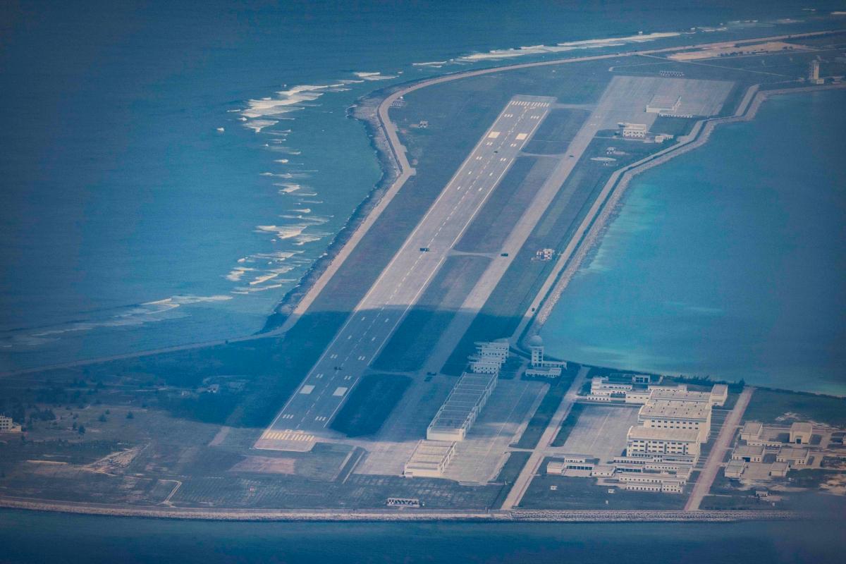
An airfield, buildings, and structures on the artificial island built by China in Subi Reef in the Spratly Islands, South China Sea, on Oct. 25, 2022. Ezra Acayan/Getty Images
China has maintained its occupation of Subi since 1988 and commenced dredging, reclaiming, and militarizing the reef in 2014. Its activities at Subi and other reefs have faced criticism from the Hague for causing irreversible ecological harm to surrounding coral reefs, violating its obligations under UNCLOS, specifically Articles 192, 194, and associated provisions aimed at protecting and preserving the marine environment.
All states claiming to the Spratly Islands, except Taiwan, have ratified UNCLOS: the Philippines in 1984, Vietnam in 1994, and Brunei, China, and Malaysia in 1996.
Nonetheless, Beijing asserts that the Hague ruling lacks legal merit and continues to uphold numerous historical claims in the South China Sea.
In December 2024, the spokesperson for the Philippine navy cautioned that Subi Reef had become a hub for Chinese vessels in the South China Sea, or West Philippine Sea.
Military Drills
The CCP’s claims to Sandy Cay coincide with the commencement of the annual joint Balikatan military drills between the United States and the Philippines on April 21, which are intended as preparation for a “full-scale battle scenario.” These exercises prompted criticism from Beijing, labeling them as “destabilizing” amid what the Philippines and other U.S. allies perceive as aggressive actions by the CCP.
“This joint training with U.S. forces enhances our capacity to secure our territory and, of course, will improve our preparedness and responsiveness to any potential situation,” remarked Philippine army Maj. Gen. Francisco Lorenzo concerning the drills.
“We all desire to resolve regional conflicts through peaceful means, but should deterrence fail, we must be equipped,” added U.S. Marine Corps Lt. Gen. James Glynn.
The drills will continue until May 9.
In early April, China and Cambodia conducted their own military drills at the recently expanded Ream Naval Base along the Gulf of Thailand’s coastline.
Reuters and The Associated Press contributed to this report.